|
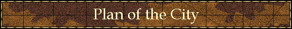
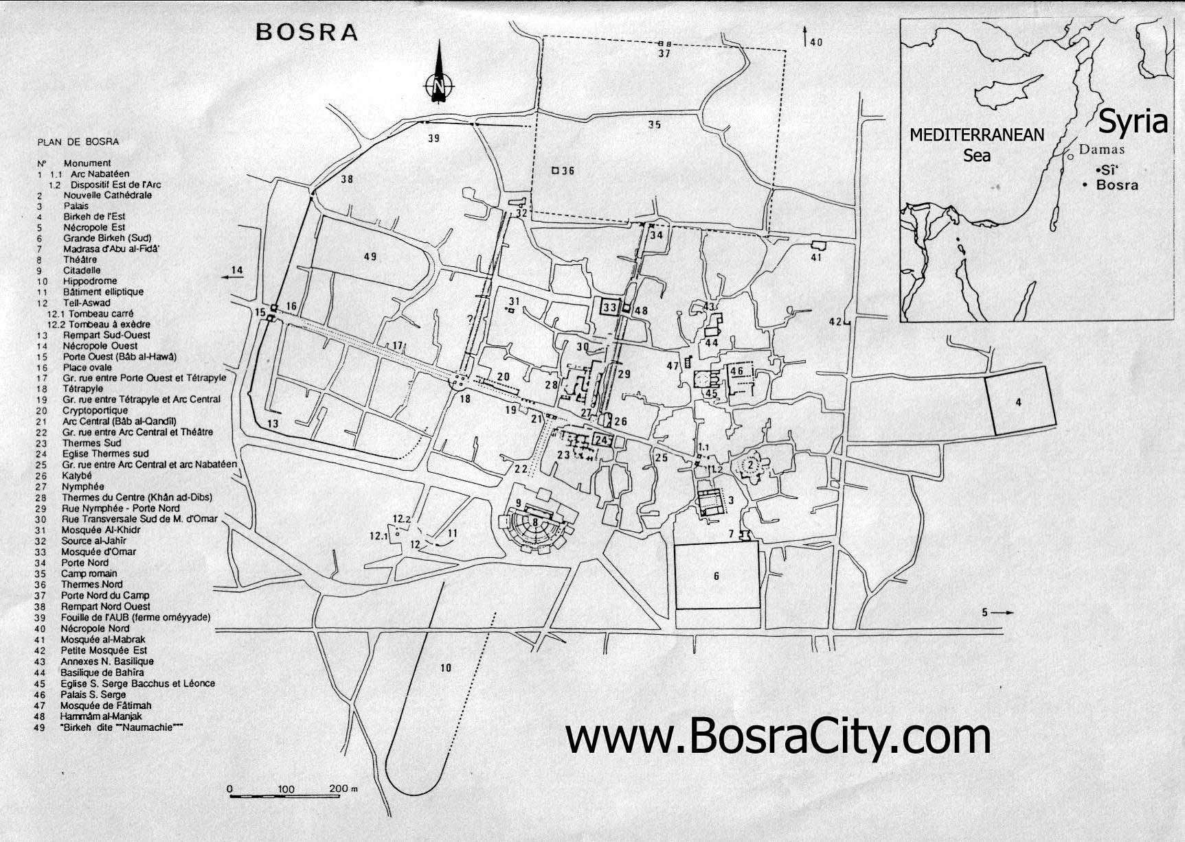
Plan of the City. The map of Bosra published
herewith is based upon the first accurate survey ever made
of the ancient city. Rey's map is by far the best that has been
published hitherto; but is wanting in certain details. Other maps
have been published; but most of them have been compiled from notes
and rough sketches made by various travellers, and are both
inaccurate and misleading. One such map which often has been
reproduced, indicates a city of symmetrical plan, with walls forming
a great rectangle, with gates regularly placed, with streets evenly
subdividing the great rectangle, and with public buildings more or
less regularly disposed with reference to the streets; quite as if
the Romans had laid out a new and complete scheme upon the site of
the more ancient Bosra. Our survey demonstrates that such a plan
departs far from the truth. The outline of the city is most
irregular, the streets follow no symmetrical scheme, and the
buildings are placed in hap-hazard fashion, indicating that the
builders of the city of the Roman period found themselves confronted
by the existing plan of an ancient Oriental city, and limited in
conforming it to a symmetrical scheme by the position of buildings
that could not be destroyed. In presenting the details of our survey
it will be observed that no attempt has been made to give the plan
of the city in other than Roman, Christian and Mediaeval times. The
plan includes remains of certain buildings that may have been in
existence before the Roman occupation of the city ; but does not
show the maze of narrow and tortuous streets of the present Arab
village. Black ink has been used to indicate the buildings of the
city that are earlier than the seventh century, and red ink to
distinguish the constructions of the earlier Mohammedan period. In
the plan of the older city solid black indicates that the walls or
columns are standing to a height of at least two metres. Shading
shows that foundations are traceable, grey dotted surfaces represent
the tops of walls that are sunken, like those of the reservoirs, and
small circles not blackened are used to mark the rows of conjectured
columns. The walls follow no regular lines nor fixed directions for
any considerable distance; that on the west of the city sweeps in a
series of obtuse angles, which almost compose a curve, toward the
northeast, and, quite imperceptibly, becomes the north wall. The
north and east walls take no consistent course, and the south wall
is entirely wanting, as the ruins stand today, except at the
southwest angle of the city where a long section of pre-Roman wall
may or may not give the course of the wall of the later period. It
is not possible to discover, without excavations, if the theatre and
the great reservoir were within the enclosure of the city ; but it
is probable that the Hippodrome was not included within the walls.
The existence of two principal gates — the North gate and the West
Gate - is demonstrable from the ruins. Three minor gates are to be
found in the northwest quarter of the city. No signs of other gates
were discovered, though they undoubtedly existed. The ancient
streets, that is the more important of them, which were provided
with colonnades, are to be traced by the ruins of their columns;
here by broken shafts that lie in a more or less direct line, there
by a few bases or stumps of columns that are still in situ, and,
occasionally, by complete columns that have been incorporated with
the walls of late buildings, or by pieces of ancient paving that
have been uncovered to form the pavement of modern courtyards. It is
only by marking such remains which are often invisible from a
distance, and by-finding out, by means of a transit instrument, that
they lie in a straight line, that the courses of the ancient streets
can be determined. The less important streets could not be traced
without excavations. There can be little doubt that the colonnaded
streets given on our map existed as they are shown. The two
principal avenues which roughly bisect the city at right angles were
not carried through the city from wall to wall, so far as we could
discouver. The Ions? avenue which begins at the West Gate passed
through the heart of the city, leading toward a slight elevation in
the east quarter of the city, and terminated at an arch less than
three quarters of the way to the east wall. This elevation, upon
which there are abundant remains of a great temple, may have
constituted a sort of akropolis. The avenue which led in from the
North Gate seems to have terminated at its juncture with the other
avenue. Two more streets lying east and west, and one more lying
north and south are to be traced in ruins of colonnades, as I have
described above; but there were in all probability other colonnaded
streets which would be revealed by systematic excavations, or even
by further search prosecuted from house to house along the intricate
lanes and by-ways of modern Bosra. We may assume from the evidence
offered in the ruins, that the colonnaded streets of Bostra were
flanked by rows of buildings which stood behind the columns on both
sides of the streets. These buildings, which may have been houses,
or shops, or both, are shown at several points on the plan where the
evidence of their existence is conclusive; but I believe that
similar structures might have been drawn on the plan along the sides
of all the streets without departing from well supported conjecture.
The buildings which date unquestionably from the Roman, or an
earlier, period are not all found to be symmetrically placed with
regard to the streets any more than the Christian buildings are. The
Theatre, the Market, and the Central Baths, do conform to the
direction of the streets, but the Palace is set without reference
either to streets or to other buildings. The Cathedral, and the
entire group of ecclesiastical buildings near it, were oriented in
such a way as to throw them out of all symmetry with the Roman
streets; and, though I believe that the colonnades remained in
place, and in use, during the. fine Christian period of the sixth
century, it is difficult to imagine how these buildings were
architecturally accommodated to the monumental plan of the city
already adopted. Other churches were placed with reference to the
direction of streets, and are consequently oriented at a different
angle from the Cathedral. One might assume that the mosques were
erected while the colonnaded streets were still intact, if it were
not for the fact that several of them have details of the despoiled
colonnades built into their walls, and that one employs as interior
supports columns from these streets ; for three of them at least are
placed near the colonnaded streets and at right angles to them. It
may be that the paved streets were still free and in use during the
early Mohammedan period, even after the colonnades which flanked
them had been wholly or in part removed. |


